


| Gisher |

The description mentions new fighting styles and various blog posts have mentioned a god of spears and a new type of spear (Doru). So how does all of this come together for spear using builds?
 Kalindlara
Contributor
Kalindlara
Contributor
|

The description mentions new fighting styles and various blog posts have mentioned a god of spears and a new type of spear (Doru). So how does all of this come together for spear using builds?
There's no new style for the spears - that mostly refers to other sections.
The doru is a spear that functions differently depending on whether you wield it as a simple, martial, or exotic weapon. Its main contribution is being better than the various simple-weapon spears.
So... not much, I suppose. ^_^
| Gisher |
| 1 person marked this as a favorite. |
Gisher wrote:The description mentions new fighting styles and various blog posts have mentioned a god of spears and a new type of spear (Doru). So how does all of this come together for spear using builds?There's no new style for the spears - that mostly refers to other sections.
The doru is a spear that functions differently depending on whether you wield it as a simple, martial, or exotic weapon.
Well, that's interesting. I don't think I've ever seen a weapon that spanned all three of those categories. Thanks!
|
|
| 3 people marked this as a favorite. |

Kalindlara wrote:Well, that's interesting. I don't think I've ever seen a weapon that spanned all three of those categories. Thanks!Gisher wrote:The description mentions new fighting styles and various blog posts have mentioned a god of spears and a new type of spear (Doru). So how does all of this come together for spear using builds?There's no new style for the spears - that mostly refers to other sections.
The doru is a spear that functions differently depending on whether you wield it as a simple, martial, or exotic weapon.
From a design perspective, I wanted to introduce a one-handed but still hefty spear similar to what Greek hoplites used. By behaving slightly differently depending on one's access to simple, martial, and exotic proficiencies, it avoids outclassing other benchmark weapons like the battleaxe and longsword. As you might guess, one of the hero-gods uses it as her favored weapon, which can be a great way to get the weapon's full proficiency benefits.
Take a look at the book, and let us know what you think!
|
Kalindlara
Contributor
|
| 2 people marked this as a favorite. |
While you're here, Mr. Compton, I'd like to thank you for bringing new Mythic content to the table. I'm glad support for that system is still showing up here and there.
|
|
| 4 people marked this as a favorite. |
While you're here, Mr. Compton, I'd like to thank you for bringing new Mythic content to the table. I'm glad support for that system is still showing up here and there.
I'm glad that you appreciate it.
Golarion has done well at establishing some of its most legendary (and largely inactive) NPCs as mythic, such as Old Mage Jatembe and the Whispering Tyrant. What's been unclear for a while is how mythic power fits into the current age, and Iblydos struck me as an ideal place in which to take the mythic concepts and shift the level of familiarity from "super rare" to "rare yet well publicized." Page 118 of Pathfinder RPG Mythic Adventures does a really nice job of presenting different scales that a mythic campaign might use. I like to think that the Iblydos mentality fits into the "Uncommon" entry more often than not.
| Evil Midnight Lurker |
| 4 people marked this as a favorite. |

Taking another look at Holomog's traits, it's too bad you can't take more than one Faith trait. Imagine an Asmodeus-worshipping lawful good cleric... casting word of chaos. And adding the good descriptor to it.
It'd make Azzy's head explode. :D
| Gisher |
| 1 person marked this as a favorite. |
Gisher wrote:Kalindlara wrote:Well, that's interesting. I don't think I've ever seen a weapon that spanned all three of those categories. Thanks!Gisher wrote:The description mentions new fighting styles and various blog posts have mentioned a god of spears and a new type of spear (Doru). So how does all of this come together for spear using builds?There's no new style for the spears - that mostly refers to other sections.
The doru is a spear that functions differently depending on whether you wield it as a simple, martial, or exotic weapon.
From a design perspective, I wanted to introduce a one-handed but still hefty spear similar to what Greek hoplites used. By behaving slightly differently depending on one's access to simple, martial, and exotic proficiencies, it avoids outclassing other benchmark weapons like the battleaxe and longsword. As you might guess, one of the hero-gods uses it as her favored weapon, which can be a great way to get the weapon's full proficiency benefits.
Take a look at the book, and let us know what you think!
I checked it out, and I like it very much. It fills the space between the shortspear and spear quite nicely. It's sort of the spear equivalent to the Bastard Sword. I like the fact that a character can still use it without Exotic Weapon Proficiency. That would allow me to put off EWP a bit later in some builds.
The whole Aelyosos section is really nice, by the way. It is definitely someplace that I want my characters to visit.
| Valantrix1 |
| 1 person marked this as a favorite. |

Ok, going over this book, I found one thing that I think is missing. The new race, the Ganzi is missing its language entry. If anyone in the know could give me an idea of what they would be, that would be sweet.
 DeciusNero
|

Still going through it, and I'm very happy with this product. The Grecian hero-gods of Iblydos (as well as 'release the kraken') are rather interesting, as is Holomog's ruling circumstances and family ties. Ducharg is impressive, and I like how Arcadia is able to hold it's own against colonials.
| James Sutter Executive Editor |

Oh, I really enjoyed the new teamwork feats. The Iridian Fold itself is quite interesting, and the feats help back that up.
Hooray! :D
|
Set
|
| 4 people marked this as a favorite. |

Really loving the numbers of nonhumans in the various cities.
Aelyosos has the merfolk, sylphs, undines and assorted fey and cyclopes hanging around. Anuli has aasimars, lizardfolk and the new chaos-peeps. Dhucharg is predominately nonhuman (hobgoblin), with some samsarans, elves and oni. Radripal has plenty of vanaras and vishkanyas, as well as some tieflings (likely rakshasa-blooded...) and, of course, rakshasa (and a honey-badger-headed one, at that!). Segada has gnomes, halflings, wyrwoods and skinwalkers. And Ular Kel has a more traditional mix of halflings, elves and gnomes.
While there's religious hints aplenty in Aelyosos, Anuli and Radripal, Segada doesn't seem to have much on Arcadian gods, other than a picture of a priest of Kazutal. There doesn't seem to be a 'temple quarter' in Segada, which may give it's own hints to differences over there, or just indicate that Paizo wasn't entirely ready to pin that down quite yet, and so had this community be less religiously focused, to avoid putting a fence up prematurely and hedging out whatever neat idea shows up later for Arcadian faith(s)...
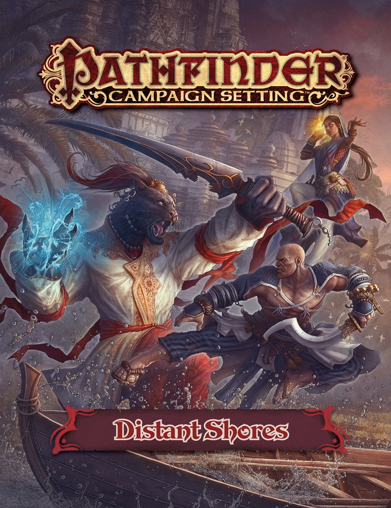
Looking at that cover, I'm like 'What's wrong with that Rakshasa (Magus?)'s hands?' And then, 'Oh yeah, they have backwards hands. That's kind of their thing...'
Some really neat stuff. Loving the artwork!
 Zeugma
|
| 1 person marked this as a favorite. |

While there's religious hints aplenty in Aelyosos, Anuli and Radripal, Segada doesn't seem to have much on Arcadian gods, other than a picture of a priest of Kazutal. There doesn't seem to be a 'temple quarter' in Segada, which may give it's own hints to differences over there, or just indicate that Paizo wasn't entirely ready to pin that down quite yet, and so had this community be less religiously focused, to avoid putting a fence up prematurely and hedging out whatever neat idea shows up later for Arcadian faith(s)...
That brings up some intriguing ideas for me about home-worship and household gods. Maybe it is a culture (at least in the city) that doesn't care much for big-temple worship and prefers private ceremonies at home.
Maybe their priesthood did something really, really bad and were banished.Maybe there was a curse placed on the city that no public temple can be erected, lest the city perish in fire, flood and plague from the other jealous gods. (Could lead to a fun campaign where PCs need to seek out a secretly built temple and destroy it, or save it...)
Lots of options!
|
|
| 4 people marked this as a favorite. |

The main reason I didn't explore religion in Segada is that the other authors were doing a bunch of stuff with deities, and we didn't want every city to have a big focus on deities. It makes good sense to focus on that in Aelyosos, Anuli, and Radripal, and we felt that was plenty.
The second reason is that I'm not 100% ready to lay out a pantheon of gods that are worshiped in Arcadia. I have a good idea of the direction I want to go with it, but I'm not completely happy with what I have, so I didn't want to paint myself into an "it's already in print" corner.
I included a mention of Kazutal and an illustration of a priest of Kazutal because I'm certain of that deity (and I'm playing a cleric of Kazutal in our developer game). What I didn't realize until now is that I didn't include any people of interest or places of interest that were religious-based. This lack of inclusion wasn't meant to define anything about the people of Segada. They're just as religious as anyone else.
| Evil Midnight Lurker |
Looking at that cover, I'm like 'What's wrong with that Rakshasa (Magus?)'s hands?' And then, 'Oh yeah, they have backwards hands. That's kind of their thing...
Not necessarily hands, in Golarion; just backwards something.
Note that honey badger guy's hands aren't palm-backward like the standard image of D&D rakshashas; instead, they're "upside-down" with the thumbs on the wrong side.
| Hayato Ken |
| 5 people marked this as a favorite. |

All we need now is a really good AP that plays in TianXia and does not start or end or whatever in the Inner Sea, but might visit the very nice TianXia city in this book as well as the Kraken Empire!
And features a lot of awesome halflings!
| Wei Ji the Learner |

Having recently gotten my hard copy, something curious came to mind about Anuli, the Crucible, and how omwa are selected.
Could someone who is best suited for the role (in part because they don't want it) be 'put up' to going through the Crucible for the 'Greater Good'?
In addition, it was mentioned that at least one man has survived the Crucible with 'undesirable results'. Would those results have been more physiological in nature, or spiritual?
Please forgive the thread-o-mancy!
| Slithery D |

Picked this up a few days ago, still working through it.
Initial impressions: I'm amused that Dhucharg and Ular Kel, but no others, have nicely rounded population numbers. I guess they use census estimations rather than exact counts like everyone else.
Dhucharg leaves me wondering how a militarily aggressive city has lasted with such weak divine casters and no arcane casters mentioned at all. Any competent level 13-15 wizard could kill the majority of the population in a few months, or at least force them to abandon the city.
| Luthorne |
| 1 person marked this as a favorite. |
It's not like 13th to 15th level characters - much less wizards - are particularly common. As the Inner Sea World Guide says on page 253...
The vast majority of humanity are "standard," ranging in level from 1st to 5th - most with NPC classes like commoner, expert, or warrior (it's uncommon for a character with only NPC class levels to be above 5th level). A significant number of a nation's movers and shakers, along with other leaders, heroes, and notables, are "exceptional," ranging in level from 6th to 10th. "Powerful" characters, ranging in level from 11th to 15th, are quite rare - typically only a handful of such powerful characters should exist in most nations, and they should be leaders or specially trained troops most often designed to serve as allies or enemies for use in an adventure. Finally, "legendary" characters of 16th or higher level should be exceptionally rare, and when they appear should only do so as part of a specific campaign - all legendary characters should be supported with significant histories and flavor.
| Slithery D |
Yeah, but these guys are supposed to be belligerent towards most of their neighbors, you'd think one of them could scrape up a group of wizards to teleport in and from flying invisibility rain fireballs down on any exposed populace every day to discourage that sort of thing. Or obliterate their armies in the field.
And many other cities in this book have a powerful spellcaster in residence. Segada has a sorcerer 17; Anuli a cleric 17, Abjurer 15; Aelysos a (mythic!) druid 16. Lots of cities must have 7-9th level casting just because of their population size and traits. Dhucharg has 5th level spells.
It's just not realistic for a military expansionist culture to succeed without any competent magical support unless their region is completely backward.
 Samy
Samy
|

There's a difference between resident and allied. They may have access to powerful magical allies who are not resident in the city.
Second, it really doesn't matter what's realistic and what's not. If they're established as successful without any magical support, then that's what they are, period. That cannot be contested. If it's in the book, then that's what they are. The reasons behind it may be explained in the writeup, they may be revealed sometime in the future, or they may never be revealed, but the status of the city is what the status of the city is said to be. The reasons are whatever.
| Hayato Ken |
Yeah, but these guys are supposed to be belligerent towards most of their neighbors, you'd think one of them could scrape up a group of wizards to teleport in and from flying invisibility rain fireballs down on any exposed populace every day to discourage that sort of thing. Or obliterate their armies in the field.
AN army of monks and rogues with improved evasion, or sacred fist warpriests with a ring of evasion laugh at that. Add in some barbarians and the rogues with uncanny dodge^^
End of your wizards.|
|
| 6 people marked this as a favorite. |
Look beyond Kaoling's borders, and I think you'll find one key reason for their continued success. To the east, Jinin is largely content to maintain its own border. To the west lies the low-population desert that presents minimal strategic threat or advantage in conquest. Chu Ye could be considered a sympathetic neighbor, insomuch as they probably agree to leave each other alone and focus on subjugating their respective populations. To the south, the three inheritor states are so busy watching out for each other that no one of them wants to risk launching an attack on Kaoling; doing so would leave that state's other borders weak.
Were Kaoling to launch a new major invasion to the south, the three states might put aside their differences in order to repel the hobgoblins—perhaps even destroy Kaoling, though that's not a guaranteed outcome. However, I could see suspicions mounting that Lingshen might annex those lands and overpower its rivals, causing friction and even betrayal as the united forces approached victory. Equally possible is that the threat of Kaoling would permanently unite the three states, though that would require truly epic battles in which to prove that the allied forces are stronger together than apart. Heck, that could even be the start of a new imperial age.
Either way, Kaoling benefits from disorganized and disinterested neighbors. It's a nation that likely would not have survived in the time of Lung Wa. For now, though, it thrives.
More to your point, Dhucharg might not have as many spellcasters in the capitol, but there might be military academies that train war wizards elsewhere in country. That remains to be seen in future publications. Consider adding them in your own campaign's take on Golarion.
| Gisher |
A bunch of stuff.
That was an awesome post! I feel like I just got a free Distant Shores Supplement!
And a belated Happy Birthday!
(For some reason I couldn't post in the Happy Birthday thread.)
 Draco Bahamut
|
| 1 person marked this as a favorite. |

Now I am curious if we would see more along the lines of humanoid cities of Golarion. We know so little of the elven, dwarven, gnome, orc, and hin cities...
|
|
| 2 people marked this as a favorite. |

Hobgoblins are generally not fans of arcane magic (which they call "elf magic"), so the lack of arcane spellcasters in Dhucharg isn't out of the ordinary. They are fond of alchemy, however, so they likely have high-level alchemists who aren't specifically listed in the city filling that gap within their society. On the whole, an army's strength is based on its size and armaments, both of which Dhucharg (and Kaoling on the larger scale) have very well covered. Even in a major military undertaking like the Mendevian Crusade most of the military consists of mundane fighters rather than spellcasters, with clerics and paladins far more common than wizards or sorcerers. Kaoling would only really be at a magical disadvantage from an attack by an extremely magical society, like Nex, but they're not really interested in waging a war on the other side of the world.
| James Sutter Executive Editor |
| 2 people marked this as a favorite. |
Initial impressions: I'm amused that Dhucharg and Ular Kel, but no others, have nicely rounded population numbers. I guess they use census estimations rather than exact counts like everyone else.
Yeah, population statistics are weird. I prefer to round because (perhaps ironically) it feels more accurate and "real" to me. People are constantly being born and dying in a city, so the bigger a settlement gets, the harder it is for me to believe a number that's exact all the way down to the individual citizen. While you can say the book is a snapshot of a given moment, and thus have that level of specificity, it just feels weird to me to give a number that will begin changing the moment the game begins.
Other people have different approaches, and that's cool too. This is just an explanation of how my brain works!
|
Crystal Frasier
Developer
|
| 2 people marked this as a favorite. |

Having recently gotten my hard copy, something curious came to mind about Anuli, the Crucible, and how omwa are selected.
Could someone who is best suited for the role (in part because they don't want it) be 'put up' to going through the Crucible for the 'Greater Good'?
In addition, it was mentioned that at least one man has survived the Crucible with 'undesirable results'. Would those results have been more physiological in nature, or spiritual?
Please forgive the thread-o-mancy!
Oh! I missed this question when it was originally posed a few months back. Apologies!
In theory, you could put forward any nominee for the Crucible, but preparing for the experience requires extensive focus and emotional clarity. A candidate is much less likely to survive if she is unwilling, so it's in everyone's best interests to either find a candidate who is already willing, or else persuade your ideal candidate to take up the mantle.
As for the effects the Crucible has on candidates, the process itself is very painful, followed by opening a mortal's mind up to the infinite potential of the outer planes. When it doesn't go well, the process either kills a candidate or (as in the case of the man mentioned) leaves deep and damaging emotional scars that can lead to instability or erratic behavior. The Crucible won't necessarily do that to all men; so far only one man (that we know about) has pushed forward into that position and survived the experience, so it's possible the ritual would have different effects on other men.
| Ambrosia Slaad |
| 4 people marked this as a favorite. |

So now that this has been out for a while, have the sales been strong enough that a Distant Shores II is a future possibility? Please?
|
Samy
|
| 1 person marked this as a favorite. |
Dropped a review. Hope it's of help to anyone.
So now that this has been out for a while, have the sales been strong enough that a Distant Shores II is a future possibility? Please?
Would sell my soul for a sequel.