


| Hobo |

And Europe is only considered a continent for cultural and historical reasons. It's just a small appendage, with a few sub-appendages, at the western extremity of the Eurasian landmass.
Well, that depends on what definition of "continent" you use. There actually isn't a formal, scientific one, oddly enough. So it's not wrong to say that Asia is a separate continent from Europe. Heck, it's not wrong to say that the far eastern edge of Asia is actually part of the North American continent, up to the Cherskiy Mountains. India is a separate microcontinent that happens to be stuck to Asia currently. The same is true of Arabia amd Turkey/Anatolia. And even "Asia" itself can be further divided into the Siberian, Amur, Kazakh, etc. continents, that happen to be traveling together under the current continental configuration, but haven't always in the past and may not always in the future.
Of course, on the other extreme, not only are Europe and Asia the same continent, but Africa, as a contiguous landmass, sharing continental shelf, should really be considered part of the same supercontinent too.
Pedantic geological nitpick of the day, sorry.
 William Ronald
|

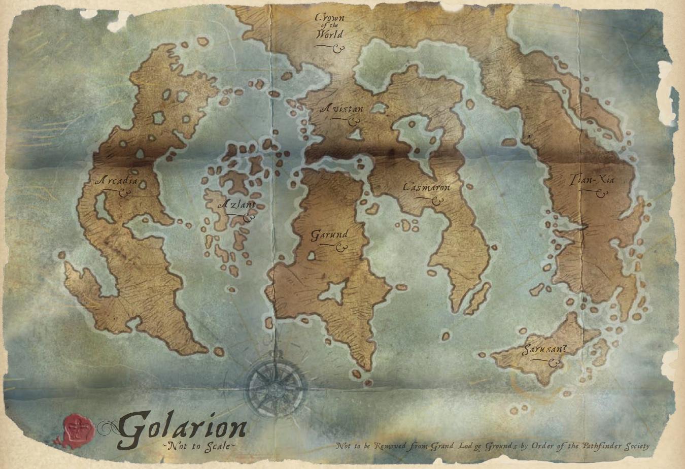
I loved seeing the map, as cartography is one of my interests. I do see how different peoples and cultures could migrate throughout Golarion. (I can see an out of Garund scenario for early humans, similar to the migration from Africa, and how humans and other species could migrate from one continent to another.
As for where things lie, we have to wait -- not for long I hope. (I imagine that several of the Tien Xia nations may be arranged in a somewhat similar fashion to their counterparts on Earth to reflect different cultural influences.) Also, I would not be surprised if there is some land at the South Pole, perhaps with some mountains and ruins reflecting some of H.P. Lovecraft's stories.
Well done!!
| MaxKaladin |
Nice map! Not quite what I was expecting as far as the details go. Somehow, I was expecting Arcadia to be "wider" and not as "tall". Likewise for Tian Xia. I wasn't expecting the big inland sea in Casmaron either. I'm not sure where I got those ideas, but that's what I pictured in my mind's eye. It will be really interesting to see how this gets "filled in" over the years.
I did some of the maps with longitude and latitude lines, but I'm not sure about making a globe out of this. I think it would be really difficult with no clue what sort of projection might be closest, especially with what James said about the oceans being too small.
| vagrant-poet |

I looked at my old map, and it wasn't too shabby a guess. Casmaron and Tian Xia are just skewed further and longer than my guestimation.
As such the rough positioning of where I guessed things to be in Casmaron should be solid, those islands between Jalmeray and Vudra are probably Iblydos.
EDIT: Even the random peninsula off the east coast was a solid guess. Unless there is some mention of it in the books and I threw it on on purpose! Maybe I'm just seeing things, I'm pleasantly surprised that I think my guess was good!
| magnuskn |

Wow, this is great. :) I need to show that to my players, so that they get an idea just how big the world they play in is. And how small they are, even at 13th level, heheheh...
|
Coridan
|

At least now we know why Golarion is still in the dark ages technologically, since every continent is oriented north/south rather than east/west of Eurasia.
 Robert G. McCreary
|

At least now we know why Golarion is still in the dark ages technologically, since every continent is oriented north/south rather than east/west of Eurasia.
Nice. :)
| Jeff de luna |

I've interpreted Casmaron using my limited understanding of climate and geography in this post, if anyone's interested.

 Kvantum
|

OK, I just did a quick overlay of the old Campaign Setting map and the new world map. They don't line up exactly because... well, they don't. I couldn't figure out how to stretch or squash them to make them match up. Avistan needed to shrink by about 25% while northern Garund stayed the same size in order to make it all fit.
URL - http://picasaweb.google.com/lh/photo/n8O2S_v0lzVQHca2_zFyvIpiSnaWluvorfuSeO a1gLg?feat=directlink or here
It really shows just how little of Golarion they've touched upon and how much there is for them (and us) to play with.
| Christopher Rowe Contributor |

OK, I just did a quick overlay of the old Campaign Setting map and the new world map.
Oh hey, that's awesome. Thanks!
|
|

OK, I just did a quick overlay of the old Campaign Setting map and the new world map. They don't line up exactly because... well, they don't. I couldn't figure out how to stretch or squash them to make them match up. Avistan needed to shrink by about 25% while northern Garund stayed the same size in order to make it all fit.
URL - http://picasaweb.google.com/lh/photo/n8O2S_v0lzVQHca2_zFyvIpiSnaWluvorfuSeO a1gLg?feat=directlink or here
It really shows just how little of Golarion they've touched upon and how much there is for them (and us) to play with.
Cool!
One thing you might want to try to get them to line up a little better is to squish the smaller image; the world map is intentionally a bit deformed, after all. The width is about right, but the height is over by about, I'd guess, 10%?
 delabarre
|

I love this map beyond the ability of words to describe.
What I particularly love about this map is the way it nicely positions itself for the Prime Meridian to pass through Absalom, as it should.
|
Kvantum
|
Cool!
One thing you might want to try to get them to line up a little better is to squish the smaller image; the world map is intentionally a bit deformed, after all. The width is about right, but the height is over by about, I'd guess, 10%?
I've tried every combination of stretch and squash I can think of to make it fit. I can either get the coastline of northern Garund to line up, or else the large lakes in Avistan line up exactly.
|
|
James Jacobs wrote:I've tried every combination of stretch and squash I can think of to make it fit. I can either get the coastline of northern Garund to line up, or else the large lakes in Avistan line up exactly.
Cool!
One thing you might want to try to get them to line up a little better is to squish the smaller image; the world map is intentionally a bit deformed, after all. The width is about right, but the height is over by about, I'd guess, 10%?
It gets the idea across, though! :)
Again, the map's not supposed to be accurate. And the further you get from the Inner Sea region, the less accurate it gets. Think of it in one way as a rough draft of the world, if you want. It's main goal is to show basic shapes and locations for the continents and seas, and that's about it.
|
The Horned One
|
| 1 person marked this as a favorite. |

Oh *that* is a most delightful map! Behold! We can now feast our eyes upon new lands to explore... and conquer!
Eric Hinkle wrote:Both. Long ago Rovagug broke free, tearing his way through a continent. He burst loose and finally saw the sun again just in time for a huge shadow to obscure it. He looked up, saw a giant meteor flying straight at him, and only had the time to lift a tiny parasol above his head before impact.I wonder, did something smash into the planet, or out of it?
Rovagug's Parasol: Otherwise known as "The most cursed artifact in existence", it will automatically shrink or grow to be exactly two sizes smaller then it's wielder, and, within 1d6 rounds after it is opened, a cosmic-sized meteor shall plunge through the sky and inflict cataclysmic destruction to everything within a 1000 mile radius. There is no saving throw -- except for the parasol itself.
|
Kvantum
|
It gets the idea across, though! :)
Again, the map's not supposed to be accurate. And the further you get from the Inner Sea region, the less accurate it gets. Think of it in one way as a rough draft of the world, if you want. It's main goal is to show basic shapes and locations for the continents and seas, and that's about it.
Oh, I'm not complaining about it at all, just saying that I couldn't get an exact overlap. It is kinda weird though that the Garund coastline matches perfectly, and the lakes in Avistan, but not both. (Plus Jalmeray never matched up right, regardless of which version I tried.)
But then again it is just the hand-drawn map from the wall of the Grand Lodge.
| Hobo |
OK, I just did a quick overlay of the old Campaign Setting map and the new world map. They don't line up exactly because... well, they don't. I couldn't figure out how to stretch or squash them to make them match up. Avistan needed to shrink by about 25% while northern Garund stayed the same size in order to make it all fit.
Could be projection issues too... the global map would have more skewing the closer you get to the poles, assuming a map centered on the equator. Since both maps have corners and a rectangular shape, I assume it's a Mercator-like projection.
|
|
Kvantum wrote:OK, I just did a quick overlay of the old Campaign Setting map and the new world map. They don't line up exactly because... well, they don't. I couldn't figure out how to stretch or squash them to make them match up. Avistan needed to shrink by about 25% while northern Garund stayed the same size in order to make it all fit.Could be projection issues too... the global map would have more skewing the closer you get to the poles, assuming a map centered on the equator. Since both maps have corners and a rectangular shape, I assume it's a Mercator-like projection.
It started out as a Mercator projection in my original, more highly-detailed version I drew for Lazzazretti, which is why Arcadia and Tian Xia seem to curve the way they do.
|
ajs
|

From the circular arcs of the coastlines to the West and North East, it looks like Golarion was hit by a much larger object than the Starstone a lot longer back in its history.
There are a number of reasons that this might be the case. An impact of the magnitude you're talking about is one possibility (Earth is believed to have had such an impact which may have created the Pacific basin and/or Pangaea, while ejecting matter that would eventually coalesce into our moon.
However, there are other possibilities. First off, we don't know what projection's being used, so this could be a very misleading map.
Also keep in mind that the active presence of deities makes the shape of the world likely more fluid than that of Earth. Was it an impact? Was it two gods (or obscenely powerful mortals) fighting that created a pressure wave, driving the continents apart?
Also, we don't know the geology of Golarion. On Earth, we have one primary upwelling rift, several hot-spots and several subduction zones along with a smattering of smaller versions of all of the above. Golarion might have a couple of large upwelling rifts that are fairly short compared to our mid-Atlantic one. This could easily produce the two oceans on either side of the central land-mass along with the bowed shape of the two outer continental land-masses.
| scifan888 |

Hello Shensen. Does Iobaria stretch stretch far enough to reach the ocean?
If so would they be willing to join an empire that encompasses Brevoy and the Castrovin Sea in return for help and stability? Would they have any objection to seaports and a navy to break the power of Cheliax and its devils?
| Shensen |

Hello Shensen. Does Iobaria stretch stretch far enough to reach the ocean?
If so would they be willing to join an empire that encompasses Brevoy and the Castrovin Sea in return for help and stability? Would they have any objection to seaports and a navy to break the power of Cheliax and its devils?
I'm honestly not sure. I've never been to Iobaria, and as I mention above, this map I managed to smuggle out is pretty innacurate. It shows the general shape and location of the regions, but the further you get from home, the less trustworthy those continental outlines get.
I HAVE seen some more accurate maps since then (and no, I don't still have them so I can't show you, unfortunately), and I can confirm that Iobaria DOES have two coastlines. They're not connected, though. One coastline to the south is on the inland sea known as the Castrovin, while another is to the north and is along a large northern ocean, the name of which I'm having trouble reading since it's all smudgy.
That northern ocean looks like it's often riddled with ice, though... and while I suppose you COULD sail from that coasline all the way down to Cheliax, you'd have to sail around all of the continent, and that'd take years, it looks like. Plus you'd probably sink along the way due to monsters or pirates or monster pirates or pirate monsters.
In other words. Iobaria has about as little interest or capability in doing anything to Cheliax's navy as possible. Less, even, when you take into account that Iobaria's still reeling from all those plagues.
| scifan888 |
I'm honestly not sure. I've never been to Iobaria, and as I mention above, this map I managed to smuggle out is pretty innacurate. It shows the general shape and location of the regions, but the further you get from home, the less trustworthy those continental outlines get.I HAVE seen some more accurate maps since then (and no, I don't still have them so I can't show you, unfortunately), and I can confirm that Iobaria DOES have two coastlines. They're not connected, though. One coastline to the south is on the inland sea known as the Castrovin, while another is to the north and is along a large northern ocean, the name of which I'm having trouble reading since it's all smudgy.
That northern ocean looks like it's often riddled with ice, though... and while I suppose you COULD sail from that coasline all the way down to Cheliax, you'd have to sail around all of the continent, and that'd take years, it looks like. Plus you'd probably sink along the way due to monsters or pirates or monster pirates or pirate monsters.
In other words. Iobaria has about as little interest or capability in doing anything to Cheliax's navy as possible. Less, even, when you take into account that Iobaria's still reeling from all those plagues.
Too bad. Thanks anyway. I wonder if I can get some spelljammer major helms from the Pactmasters of Katapesh? They act like the Arcane and since nobody actually sees their actual appearance they could actually be members of the Arcane race. What do you think?
| Shensen |
Too bad. Thanks anyway. I wonder if I can get some spelljammer major helms from the Pactmasters of Katapesh? They act like the Arcane and since nobody actually sees their actual appearance they could actually be members of the Arcane race. What do you think?
I think that's a pretty good way to get yourself killed, since outer space doesn't work like it does in Spelljammer in Golarion... it works more like outer space.
AKA: you'd need a magic bird like a shantak or a spaceship like the ones crashed in Numeria.
So I hear. I've not spent much time in outer space yet.
|
Deadmanwalking
|

They act like the Arcane and since nobody actually sees their actual appearance they could actually be members of the Arcane race. What do you think?
Dark Markets, the Katapesh book answers the question of what the Pactmasters are. It's also just generally neat.
| scifan888 |
I think that's a pretty good way to get yourself killed, since outer space doesn't work like it does in Spelljammer in Golarion... it works more like outer space.AKA: you'd need a magic bird like a shantak or a spaceship like the ones crashed in Numeria.
So I hear. I've not spent much time in outer space yet.
Actually I had considered the differences already. I'd thought about using the helms inside airtight vessels and taking advantage of their speed and carrying capacity especially in atmosphere.
| Kajehase |

I'd say it depends on who is doing the invading. Nidal probably would help out unless their rulers feel they can profit by sitting things out (and that, presupposes that they're pretty sure Cheliax will lose, because if Cheliax wins, and Nidal didn't help...).
|
Zeugma
|

I'd say it depends on who is doing the invading. Nidal probably would help out unless their rulers feel they can profit by sitting things out (and that, presupposes that they're pretty sure Cheliax will lose, because if Cheliax wins, and Nidal didn't help...).
The Umbral Court can well afford to bide its time. Egorian grows ever more complacent and reliant on Pangolais for her shadowbeasts and nightmare steeds, while the Overdiocesan of Nisroch has several irons in the fire with the pirates of the Shackles. It looks like Nidal is truly a reed - she bends in the political winds, but does not break.
| DrJonesDk |
Hobo wrote:It started out as a Mercator projection in my original, more highly-detailed version I drew for Lazzazretti, which is why Arcadia and Tian Xia seem to curve the way they do.Kvantum wrote:OK, I just did a quick overlay of the old Campaign Setting map and the new world map. They don't line up exactly because... well, they don't. I couldn't figure out how to stretch or squash them to make them match up. Avistan needed to shrink by about 25% while northern Garund stayed the same size in order to make it all fit.Could be projection issues too... the global map would have more skewing the closer you get to the poles, assuming a map centered on the equator. Since both maps have corners and a rectangular shape, I assume it's a Mercator-like projection.
The size of the global map and the Inner Sea map suggests that Golarion is about the same size as Earth?
 Cpt_kirstov
|

The size of the global map and the Inner Sea map suggests that Golarion is about the same size as Earth?
Yup, that way everyone works from what they know and astronomers don't haveto keep saying "that's not how a planet this size would act"