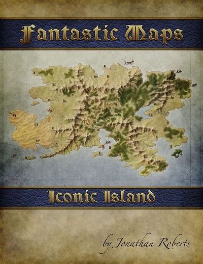
Jonathan Roberts, cartographer for George R.R. Martin's Lands of Ice and Fire, and The Breaking of Forstor Nagar, presents a new kind of Fantastic Map: "Iconic Island!"
The map pack includes a collection of images sized at 5100px by 3300px, allowing for 17" by 11" at 300dpi. The map is provided in three versions:
Totally bare: just the terrain and nothing else
With icons: a collection of locations are marked, but their significance is left up to you
With icons and hex grid: the grid allows for easier distance measurements. The hex scale was loosely chosen to be around 6 miles a hex, but feel free to set it to whatever works best for you.
Sixteen icons are provided, each with as PNGs with transparent backgrounds, to give you the ability to customize the island you require for your own adventures.
Product Availability
Fulfilled immediately.
Are there errors or omissions in this product information? Got corrections? Let us know at
store@paizo.com.
This installment of the Fantastic Maps-series by Jonathan Roberts is rather different from the other installments of the series in that it does not come as a pdf and depicts another type of map:
Whereas the series usually depicts some area with grids to use as combat/environment maps in the small scale, this instead takes one massive island as you'd depict it on a detailed treasure map from a bird's eye's view and provides an overview of an island.
Beyond the high-res jpeg of the island per se, we also get one version with icons. Icons? Yes, 16 .png icons are part of the deal: The brown icons range from anchor, axes, caves, 2 city-icons, 2 keep-icons, a ruin, a flag, a serpent, a skull, a sword, a wreck and icons for temples, towns and villages.
These icons are present on the 3 alternate versions of the high-res jpegs of the island - there is one sans any grid with the icons, one that also sports hexes in addition to the icons and a b/w-version of the map with the hexes and icons.
Conclusion:
The map provided by Jonathan Roberts depicts a beautiful island rife for the population by the DM, be it with or without icons. In any exploration/nautical context, this map should come handy, whether it is for skull & shackles, razor coast or journeys to the west - this place should be interesting for you. However, I also have something to complain about: What if the Dm wants to print out the map of the island, treasure map-style (you know, glue it together, give it the coffee-treatment, go all the way), there is no way to do that. In contrast to other Fantastic Maps-installments, there is no blown up version of the map. While I get how that is usually intended for use with miniatures, I think a hex-studded version of the map, blown up (perhaps so its entirety spans 4-8 pages) and made into a massive, real treasure map would have greatly expanded the usefulness of the installment. Due to the lack of said feature, I'll only settle for a final verdict of 4 stars for this installment.
If you are into world creation this is a bit of a treat: a beautifully-mapped island all ready for you to decide what's where and what is going on there.
The only features provided are topographical: rivers, mountains, and some indication of vegetation - forests in the main and something that I think is supposed to be marshy land. Oh, and a very bare coastal area with no rivers that is probably desert. It all looks pretty natural and realistic with the rivers rising in appropriate places in the mountains and winding their way down to bits of the coastland the right shape for river mouths.
There are actually FOUR versions provided: a plain map, one with icons, one with icons and hexes and a greyscale version of the icons & hexes one. If you don't care for the pre-positioned icons they are all provided as transparent PNG files which are a doddle to locate where you think they ought to go. As well as assorted township/castle type icons, there are crossed axes (site of an historic battle, perhaps?), a shipwreck and a delightful sea-serpent - which reminds me of the variant of my university site plan I drew, place was built round a lake so I put a sea-serpent much like this one in it... then I was approached by the administration to update the 'official' plan...
There are other icons too: anchor, sword, skull, cave-mouth, and flag. You can decide what they are supposed to represent. Don't forget to do a map legend (key) to show what your icons mean, or to add a scale. A scale of about 6 miles to a hex is suggested, but you may have other ideas. The one thing that's missing is a compass rose, so that you can indicate which way is north, but that's a minor quibble and a suiitable symbol is easy enough to find.
This is really nice, and I'm sure my characters' boots will be tramping over here 'ere long!