


 Jason Nelson
Contributor, RPG Superstar 2008 Top 4, Legendary Games
Jason Nelson
Contributor, RPG Superstar 2008 Top 4, Legendary Games
|

I like the part about module locations. I think that's a fun addition.

| Urizen |

Whoa? Where'd my post go? I was asking for a framed option.
Your original thread may have not gotten the love and you got pre-empted to the cooler kids thread? ;)
 Andrew Phillips
|

I like the part about module locations. I think that's a fun addition.
+1, given the size of this map set the module locations should be so detailed moving a group of PCs around the world should much more fun(less work for us Too busy DMs).

 Kvantum
|

44"x72" would be my guess, assuming four 2x4 maps of 8.5" x 11" panels.
|
|

So how large is 32 panels?
One panel = 1 page. So... very big.


| Todd Stewart Contributor |

I still have room on my office wall for more art or posters. This works. :D

| Davelozzi |

Yep. As a huge fan of maps, but not at all a fan of previous map folios, I have to say this one sounds damn cool and I am looking forward to it.
| Twin Agate Dragons |

He Who Walks in Blood wrote:So how large is 32 panels?One panel = 1 page. So... very big.
Holy Canoli, tha't huge! beams with glee
|
|
| 1 person marked this as a favorite. |
Is that one piece of paper, or will it come piecemeal?
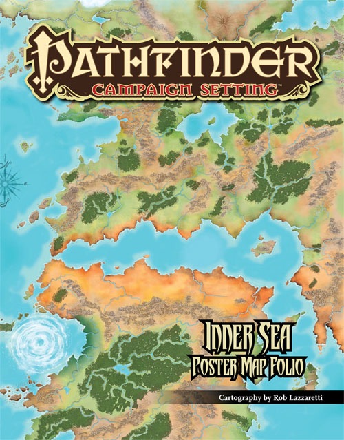
It'll be on 4 poster maps. Those who remember the map of the World of Greyhawk we put into Dungeon #117–#120 or thereabouts will know what we're aiming at... although on heavier paper stock.
Having helped put the Greyhawk map together... I'm actually a bit terrified of this one...
| Evil Lincoln |

Is the cartography new in this one?
Are we going to see corrections like the latitude of the Crown of the World — or maybe some edge-of-the-map hints at something like vagrant-poet's incredible extrapolations? (just a little inset of the map's place in the global map would be nerdgasmic)
Navigation lines? How are the 4 poster maps oriented? Will the assembled map be portrait format still? If so, can you plan ahead to have it line up with whatever eastern map is eventually released so we can can have a megamap for our mancaves?
I'm a bit of a cartographile and the map folios finally appear to be coming into their own. Really, really excited for this one.
|
|
Is the cartography new in this one?
Are we going to see corrections like the latitude of the Crown of the World — or maybe some edge-of-the-map hints at something like vagrant-poet's incredible extrapolations? (just a little inset of the map's place in the global map would be nerdgasmic)
Navigation lines? How are the 4 poster maps oriented? Will the assembled map be portrait format still? If so, can you plan ahead to have it line up with whatever eastern map is eventually released so we can can have a megamap for our mancaves?
I'm a bit of a cartographile and the map folios finally appear to be coming into their own. Really, really excited for this one.
The cartography more or less HAS to be new. We want to put more tags on, but more to the point we want to put new terrain features and islands and stuff in as well. And I'd also like to remove the band of white across the top of the map, and reduce the size of Droskar's Crag down to normal.
The assembled map will still be in portrait format.
As for the map of the entire world... this map will NOT be in this product. That might be a good project for another day. That said... the new revised hardcover campaign setting will indeed have a map of Golarion, including all of its continents. It'll only be a half-page in size, but it'll do the job for now!
| Evil Lincoln |
The cartography more or less HAS to be new. We want to put more tags on, but more to the point we want to put new terrain features and islands and stuff in as well. And I'd also like to remove the band of white across the top of the map, and reduce the size of Droskar's Crag down to normal.
Excellent well! The map to beat, in my humble opinion, is that original MERP map folio from way back. Assembly was a total nightmare, but the cartography was insanely beautiful and inspired if not accurate.
| vagrant-poet |

Are we going to see corrections like the latitude of the Crown of the World — or maybe some edge-of-the-map hints at something like vagrant-poet's incredible extrapolations? (just a little inset of the map's place in the global map would be nerdgasmic)
Thank you!! :D
As for the map of the entire world... this map will NOT be in this product. That might be a good project for another day. That said... the new revised hardcover campaign setting will indeed have a map of Golarion, including all of its continents. It'll only be a half-page in size, but it'll do the job for now!
Oh wow! That made me want to buy it more than anything else!!!! Or as much as... Oh god! Roll on September!!!


| tdewitt274 |

So, will this be in PDF format as well? Single page and Multiple page formats? With the floating text so that if we snag the picture it doesn't have the labels on it?
Please? : )
| Davelozzi |
This is going to be great! I agree that the AP sites are a nice addition.
I don't know, I love having a reference map of adventures sites, like the one that appeared in the existing Campaign Setting, but I don't know that I would want to see them on a giant map like this. I'd want to be able to show it to my players without the spoilers. I hope it will at least be all locations shown in the sense of marking the location by name instead of by number. In other words...

| Caen |

Please, please, please do NOT put on numbers/locations for advnture path locations or pathfinder modules... nothing breaks the 'real' feel of a map like doing that, plus it's too much info for players... Goodman ruined the Aereth maps by doing this... and also, this dates the map, as later adventures/module locations are obviously not detailed... so in other words......... what Davelozzi said...
|
|
Folks who remember the giant Greyhawk map we did in Dungeon several years ago will know the type of map that we're aiming to do do with this. It most assuredly won't have module numbers or PF volumes on it. "Xin-Shalast" will be labeled as "Xin-Shalast."
|
Matthew Morris
RPG Superstar 2009 Top 32, 2010 Top 8
|

I'll likely end up buying two. One to hang on the ugly blue wall in the spare bedroom and one for my shelves.
Maybe 3, one for the ugly blue room, one for the Hermit-cave(tm) and one for my shelves.
| Sharoth |

I'll likely end up buying two. One to hang on the ugly blue wall in the spare bedroom and one for my shelves.
Maybe 3, one for the ugly blue room, one for the Hermit-cave(tm) and one for my shelves.
+ 1 to that. I am guessing three copies for myself. One for my wall, one for me, and one for the player(s).


| Zaister |

Damn, I need a free wall...
| Majuba |

Damn, I need a free wall...
No kidding.. staring at my framed Campaign setting one and trying to imagine it four times bigger (2x2)... wow. I can't figure out if I'm glad it's broken into four or not. I know I'd tear it, were it a single sheet.
|
|
So, will this be in PDF format as well? Single page and Multiple page formats? With the floating text so that if we snag the picture it doesn't have the labels on it?
Please? : )
Should be...
| gigglestick |

OMG! This I cannot wait for!
Need to buy at least 2. Maybe 3. (Donate one to the FLGS...)
 GarnathFrostmantle
|

NO NO NO!
HOW are you going to make me wait till November for a preorder. The book "preoder" starts or comes out, whichever, in September. How dare you make me wait 2 WHOLE months for a large super map.
It's like waiting in line for the DMV. I'm an addict, feed me know.
*pouts in corner*
Rant aside, this is the map I have been longing for. I'm really excited for hanukkah and xmas this year!

|
Purple Dragon Knight
|

LOOOOOOOOOOOOOOOOOOVE! **choke** arghh... *cough* *cough* *swallow* LOOOOOOOOOOOOOOOOOOOOOOOOOOOOOOOOOOOOOVVE!!!!


|
Snorter
|

Will this be available in a GM's version (all the info), and players' version (well-known landmarks, but without any scenario spoilers)?
I can understand not wanting to make two printing runs, but at least if there's a PDF, we can do this ourselves.
In the event there is a PDF, please could the text be split into at least two layers; one of commonly-known information, and the other of scenario-specific locations?
That way, a GM can extract the area he wants, and edit away one or more of the text layers, leaving the PCs' intended destination in full view, while removing all trace that The Underground Temple of Horrendous Doom lies directly in their path.
[EDIT: Vic's earlier reply fills me with some confidence. However, I'd still suggest that there be at least two different text layers, if possible.]
|
Shem
|

I would like to PDF to come in one page that can be taken to a print shop and printed as one map. I have a 3x4 foot map on my office wall of the current Campaign Setting PDF and I would love to be able to do that again with the new one.
Thanks...


|
Michael Brock
|

I'm going to need two. One for my collection. The other will be for me having put on a board, coated, and hung in my game room.
| Joe Towers |

I'm going to need two. One for my collection. The other will be for me having put on a board, coated, and hung in my game room.
I'm only going to get one, which will likely stay folded and unassembled somewhere. Maybe tucked into one of my hardcovers.
Unless I can think of a good way to convince my wife that this is the newest fashion in wall-paper. Maybe I can trick her in thinking it is the newest French, toile style. Then I may need several maps!
Will these come in any varying color schemes?
| Swiftbrook |

Is this going to be available separately as a PDF? Are subscription people going to get a PDF on this? I can see a lot of uses for the PDF.
-Swiftbrook
|
|
Is this going to be available separately as a PDF? Are subscription people going to get a PDF on this?
Yes and yes.